Camino Frances Elevation Profile | All Stages Printable PDF
Camino Frances Elevation Profile | All Stages Printable PDF
Couldn't load pickup availability
Know every climb and descent on the Camino Francés before you walk it, without opening your phone.
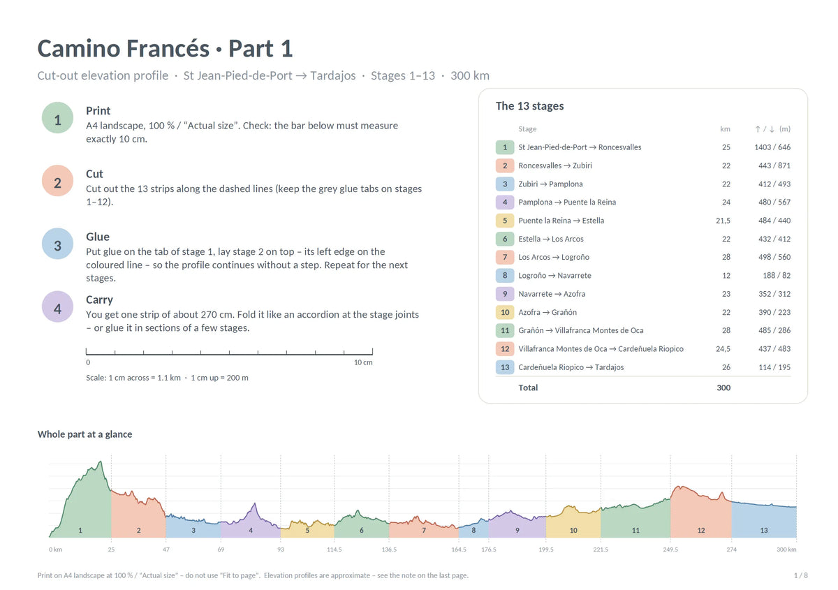
This printable elevation profile covers the full Camino Francés, from Saint-Jean-Pied-de-Port to Santiago de Compostela, in all stages. It is built from real GPS tracks of the main route, not the alternatives. You print it at home, cut it, glue it, and fold it like an accordion into a slim strip that fits in a pocket or the lid of your backpack.
Why have your elevation profile on paper?
- Save your phone battery. On long days, a phone is also your camera, map and bank. Paper never needs charging.
- No signal needed. The Pyrenees, the Meseta and O Cebreiro have patchy coverage. A paper profile works anywhere.
- See the whole day in one glance. Unfold one stage and you see the climbs, the long flat stretches and the descents. You can pace your water and breaks, and plan where to stop.
- Easy to share. Pilgrims can gather round one strip at a café table and decide where to sleep.
What you get
- A PDF with the full route in 3 parts.
- Each stage has its own coloured strip, so you can see where each stage begins and ends
- Highest and lowest points labelled on every stage, plus distance, total ascent and descent
- A short step-by-step guide: print, cut, glue, fold
- Clear scale: 1 cm across = 1.1 km, 1 cm up = 200 m, with a 10 cm check bar to confirm your print size
- Soft, easy-to-read colours, with a clean design that works on any home printer
How it works
- Print on A4 landscape at 100% (“Actual size”).
- Cut out the strips along the dashed lines.
- Glue the strips together using the tabs.
- Fold it like an accordion. It takes almost no space in your pack.
Instant download
You receive the PDF immediately after purchase.
Elevation profiles are approximate and based on available route and elevation data. Actual terrain and elevation figures may vary depending on the data source and route taken.
This is a digital product (PDF). No physical item is shipped.
Perfect for
First-time pilgrims, repeat walkers, anyone doing the full 780 km or just a section, and people who like to prepare and plan on paper. It also makes a good gift for a friend heading to the Camino.
Item details
Item details
Elevation profiles are approximate and based on available route and elevation data. Actual terrain and elevation figures may vary depending on the data source and route taken.
This is a digital product (PDF). No physical item is shipped.
How to use
How to use
- Print on A4 landscape at 100% (“Actual size”).
- Cut out the strips along the dashed lines.
- Glue the strips together using the tabs.
- Fold it like an accordion. It takes almost no space in your pack.
Delivery
Delivery
Download a file on the checkout page.
Additionally you'll receive the PDF on your email after purchase.
Return policy
Return policy
We hope you to love it, but if you need to make a return, breathe easy - we're here to support a seamless process.
For details on how to initiate a return and ensure a smooth process, please read our dedicated page.
Payment & Security
Your payment information is processed securely. We do not store credit card details nor have access to your credit card information.